

Electronic World Atlas for Amateur Radio
| Features | Screenshots | Iono Maps | Integration |
Electronic World atlas for Radio Amateurs. Scrollable World map with smooth zoom, DXCC territories, province/state prefixes, Grid Squares, CQ and ITU Zones in the rectangular, azimuthal and Globe projections, 3D relief, Gray Line, city and island index, unique hierarchical prefix database, local time with DST for all cities, islands and call areas, unique ionospheric maps.
Integrates with HamCAP, IonoProbe, Band Master, and many 3-rd party programs.
 Prefixes
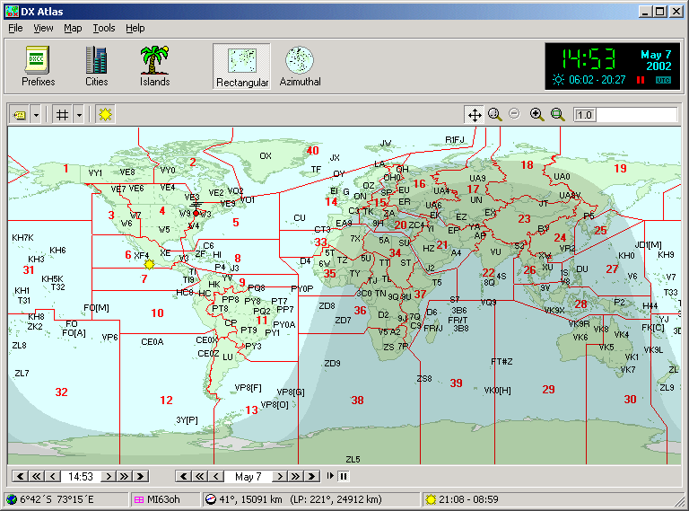
Call area boundaries and prefixes are shown on the World map in addition to the DXCC boundaries and prefixes. Each prefix has a hint with a country and province name. Click on a prefix to find it in the Prefix Database.
ZonesCQ Zone and ITU Zone boundaries can be switched on and off. Move your mouse over the zone label to see the official definition of the zone.
Grid SquaresThe Maidenhead Locator map displays 2-character and 4-character grid squares. You can mark worked and confirmed squares and add comments to each square. The Grid Square calculator converts between the latitude/longitude and the grid square locator.
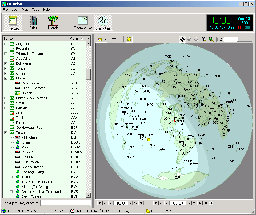
Azimuthal mapRectangular, Azimuthal and Globe projections are available. The Azimuthal map center can be changed with a single mouse click to see how the World looks from a DX location.
 Navigation
Zoom in and out, scroll or re-center the map, switch between the projections and turn individual layers on and off with your mouse. Antenna bearing anddistance for the point under the mouse cursor are shown on the status bar.
Gray Linecan be turned on and off, or shown for any specific date and time. Sunrise and sunset time is calculated automatically for the current point and for all gazetteer entries.
Prefix DatabaseBrowse the visual, hierarchical prefix database that comes with DX Atlas. This database includes current and old prefixes of countries and provinces, prefix blocks allocated to club stations and reserved for special events, and much more. Each entry has a lot of associated data, including CQ/ITU Zone, Time Zone, DXCC territory and ADIF number. We have released our Prefix Database as a public domain dataset.
GazetteersDX Atlas includes a detailed City and Island index. Double-click on any island or city to find its location on the map, or right-click to see the details such as latitude and longitude, country, province, and city population.
Local timeis displayed for all territories, provinces and cities, for the current date/time and for the dates in the past and future. This function uses a database of Time Zone and DST changes since 1945.
Automation3-rd party programs can control DX Atlas and even plot their own data on the map via COM or OLE Automation.
Minimum system requirements:
- CPU: Pentium 166 MHz
- RAM: 32 Mb
- OS: Win95/Win98/WinNT4/WinME/Win2000/WinXP
- Video card: 640x480, 256 colors
- Disk space: 9 Mb (+55 Mb for optional hi-res relief data)
Ionospheric maps in DX Atlas
DX Atlas includes a set of dynamic, interactive ionospheric maps. Each map displays the selected parameter, such as the F2 layer critical frequency, D layer peak electron density, etc. The parameter value under the mouse cursor is displayed on the status bar, and various levels of shadows show how the parameter is distributed across the Globe.
If you had to drive from point A to point B, would you prefer to have the driving instructions or a road atlas? The task looks easier in the first case: you just follow your instructions, and you do not have to read the map. This works fine until you discover that the exit mentioned in the instructions is closed. Now you are helpless! You do not know what other routes exist. If you have a roadmap, however, you can easily find an alternate route. Ionospheric maps are like a road atlas to a DXer, they allow you to find 'alternate routes' even if the 'driving instructions' produced by the propagation prediction programs fail to work.
To use the ionospheric maps, one needs to understand how the ionosphere works. As you probably know, the F layer reflects radio waves, and the D layer is responsible for signal absorption. By checking the F layer's critical frequency along the path, you can tell if the high bands are open, and the D layer density gives you an idea how strong the signal is going to be. There is much more information that can be extracted from the maps. For example, chordal propagation is likely to occur in the areas where the F2 critical frequency (foF2) or height changes quickly along the path, and path bending can occur if there is a significant transverse foF2 gradient.
The more you know about the propagation mechanics, the more useful ionospheric maps are to you. Use your knowledge to interpret the maps, and use the maps (with a good book on propagation) to improve your knowledge. Propagation 101 by Bob Brown, NM7M is an excellent example of such book. You can download it from our Web site: Prop101.zip.
Software compatible with DX Atlas
| The programs and datasets listed below integrate with DX Atlas and display their own data on the map. This list is provided as a convenience, Afreet Software Inc. is not responsible for the content and software on the listed sites. |
DXtreme Reception Log by DXtreme Software
DXtreme Reception Log - Advanced Edition is our logging program designed for radio monitors (SWLs and others).
DXtreme Station Log by DXtreme Software
Multimedia Logger for Hams and SWL's.
IOTA List by Joe WA6AXE
IOTA List for DX Atlas.
USA-CA List by Joe WA6AXE
USA County List for DX Atlas.
RDA List by Joe WA6AXE
The Russian Discticts Award (RDA) List for DX Atlas.
Pin List generator for DXBase 2007 by Joe WA6AXE
Description from the author: "A report that creates DXCC 'Pins' for the DX Atlas program"
DXBandMap by Gerry, W1VE
Description from the author: "A new kind of Bandmap for Writelog! See your spots plotted on a world map, along with Propagation and Greyline information"
miLog by the miLog team (K7MI - K6GNX - N6GDA - N7ON)
Description from the authors: "Highly integrated Logging, DXing, Contesting and Station Control Software"
IOTA List by Gérard 14SD330
IOTA List for DX Atlas, 92660 entries; Lota and Sota lists.
DXLab Suite of free DXing applications by Dave, AA6YQ
Description from the author: "A suite of interoperating applications designed to automate DXing activities".
CommCat by COMMSOFT
Description from the author: "Breakthrough program provides tools to give you the advantage in pile-ups".
DX Tracker by Ed Lyons, KD6IET
Description from the author: "DX Contacts Logging Program for the HF Amateur Radio Enthusiast".
IOTA.LST by Nikolay, EU6TV (SK)
IOTA list for DX Atlas, freeware and shareware versions. Nikolay also provides several island lists for national island awards in the DX Atlas format.
PC-HFDL by Charles Brain, G4GUO
Aircraft communications monitor.
Description from the author: "PC-HFDL is a windows based decoder for the ARINC 635-3 HF data-link protocol".
CQ Log by Oleg, RA3DCT
Description from the author: "CQ Log is the powerful logging program. It is the total control center for everyday on-the-air activities. Full-featured logging of QSOs; statistics for DXCC, HOLYLAND, IOTA, RRA, P-100-O, RDA, WAS, and WAZ awards; support for QRZ!, RAC, and RIC databases; contest mode. It is possible to save up to 3 pictures for each SSTV-QSO. Two-way data exchange with MixW2 and DigiPan. RIG control, DX-managers database, printing of QSL-labels and much more".
DX Base 2003 by Scientific Solutions
Description from the author: "DXbase 2003 is perhaps the most comprehensive Windows 95/98/2000/NT/ME/XP logging software ever created. It features current technology and gives you the same professional "look and feel" as other professionally developed 32 bit software".
LOGic6 by Personal Database Applications, Inc.
Description from the author: "The ultimate in flexible logging software since 1989, featuring user-defined fields, user-configurable screens, tracking forany award, contesting, and more".
AR-Cluster by AR-Technology
Description from the author: "AR-Cluster is next generation Windows based DX-Cluster system offering built-in Internet connectivity".
AALog 2.1 by The DXSoft Group (RZ4AG)
Description from the author: "AALog is a comprehensive logger program designed for amateur radio station operators. It looks like your paper log an uses all power of your computer".
ISLAND.LST by Nikolay, EU6TV (SK)
A drop-in replacement for the standard ISLAND.LST. Includes over 15,000 islands.
Cluster Monitor by The DXSoft Group (RZ4AG)
Description from the author: "Cluster spot history, latest spots in a separate window, full information about DX, announcements, WWV reports, flexible sorting and filtering. Full DXAtlas support. Integrated dial-up support".
CITY.LST by Vlad, 4K6D
DX Atlas City List in Russian, a drop-in replacement for the standard CITY.LST.
TRX Manager by Laurent, F6DEX
Description from the author: "TRX-Manager is an original and innovative control and logging program for Radioamateurs. It supports almost all the functions of Yaesu, Kenwood, Icom... Transceivers fully integrated in a comprehensive package for Radio Amateurs making easier and more effective SW Listening, DX Spotting, Logging, Award tracking, Satellite, Rotator control and much more... ".
MixW by Nick, UT2UZ
Description from the author: "Multi Mode Operating Software for Win PC with sound card. Suports TNCs, CATs and antenna rotors. Regular and contest logging formats. All of the popular modes (including phone) are suported".


